


Standing at the confluence of the Karakoram, Hindu Kush, and Himalayas is a humbling reminder of nature’s scale.
Over four decades, Nepal has never lost its beauty, but it has changed. Since the author’s first trek in 1981 to the base camps of Mount Everest, Lhotse, and Nuptse, he returned many times. The towering peaks remain, but the atmosphere has shifted. Trails once quiet now feel crowded, particularly around Annapurna, where commercialization has steadily reshaped the experience. Even the vast Khumbu Glacier, once seemingly untouchable, tells a story of change.
So, the search began for something wilder, less traveled.
It led north to Pakistan’s Baltistan, into the rugged grandeur of the Karakoram. Here, the scale is overwhelming, the trails quieter, and the welcome disarmingly warm. This is a landscape that feels closer to the essence of high-altitude exploration, raw, vast, and largely untouched.

The town of Skardu serves as a convenient gateway.

Often referred to as the “Mountaineer’s Paradise,” it provides access to four of the world’s fourteen peaks above 8,000 meters, making it an ideal destination for both elite climbers and enthusiastic amateurs alike.


Yet the mountains demand respect. A memorial here commemorates four renowned mountaineers who lost their lives on K2 during the winter expedition of 2021. Among them was the legendary Pakistani climber Muhammad Ali Sadpara, a national hero who summited eight of the world’s fourteen highest peaks, achieved the first winter ascent of Nanga Parbat helping to define Pakistan’s mountaineering legacy.

Beyond Skardu, flowing through this dramatic landscape, is the mighty Indus River, one of the subcontinent’s great arteries.


Obstacles on the way

In 2023, an 18-day trek began with a small group of six trekkers (2 Marconian, 1 Italian, 1 Canadian, 1 Thai and a German), supported by the team of ‘Karakoram Expeditions’, eight mules, two cooks, twelve porters and chief guide Mohamad.

The journey started in the fertile Braldu Valley, where temperatures still climbed to 36°C.

Soon the surrounding became more rugged.


It changed behind every bend.


As the trail ascended beyond 4,000 meters, the tents were directly pitched on the ice of the immense Baltoro Glacier, surrounded by a skyline of jagged granite towers.


At Concordia (4,500 m), often called the ‘Throne Room of the Gods’ and at the meeting of great glaciers including the Godwin-Austen Glacier, the mountains reveal their full scale.

And there it is: K2.

The confluence of the Godwin-Austen Glacier.

At 8,611 meters, K2 is not just the second-highest mountain on Earth, it is the most formidable.

Nicknamed ‘The Savage Mountain’, it rises with a severity that makes even Everest seem approachable by comparison.

The K2 Base Camp (5,135 m)

With its base camp just 8 km away, Broad Peak (8,047 m) is locally known as ‘Falchan Kangri’. The world’s No. 12 is famous for this nearly 1.5km long massive summit ridge looming over the glaciers.

The following year brought new horizons. At Rakaposhi (7,787 m), the so-called “House Mountain,” the scale feels almost intimate as it towers directly above the lush Hunza Valley.

Up hill

The view back down to the Hunza Valley.

The view forward.

On the way to the base camp at 3540m.


A spectacular Glacier

Ice walls
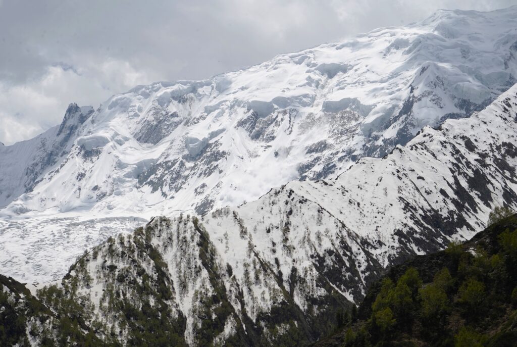

100 km further south and geographically located in the Himalaya, the winding road to start the trek towards Nanga Parbat.


The road ends at Tattu.

From here horses carrying food and essentials are your ‘best’ friend.


And the strong locals

The huge Rakhot Glacier flowing down from the north side of Nanga Parbat.


Narrow steep trails next to a massive force of rock and ice.

From ‘Jillipur Peak’, (3650m) the view back!

The vertical ice face ahead.

The first sunrays tickling the peak.

In all its glory: ‘The Killer Mountain’, due to its high number of fatalities, rises in stark isolation.

With 4600m from its base it features the highest mountain face on earth.

With 8126m the number 9 in the world. Because of its extreme difficulty it demands the highest technical skill. Its history is etched with both triumph and tragedy.
Yet it is Hunza Valley that lingers most vividly in the memory. Once a vital artery of the ancient Silk Road linking Kashgar with Islamabad, the region remains steeped in history. Clear evidence of these ancient routes can still be seen today in the rock-carved paths high above Hunza River. Forgotten trails still trace the journeys of traders who once carried silk, spices, and salt across these mountains centuries ago.

Centuries-old forts continue to guard the valley. They stand as enduring reminders of the region’s strategic and cultural importance.
Altit Fort


Baltit Fort


Among the valley’s most recognizable landmarks are Ladyfinger Peak, locally known as Bublimotin, rising to around 6,000 meters, and nearby Hunza Peak (6,270m), both towering dramatically above the valley floor.

More than the landscape, however, it is the people who define the region. Visitors are welcomed with a warmth that feels entirely genuine, often invited to share tea, stories, and dried apricots from local orchards.


For further information, reference is made to the author’s publication on this website: Journal → Asia → Pakistan → Hunza Valley.
Good hours’ drive up the valley on the Karakorum Highway (built with Chinese support) beyond Passu, the Hussaini Suspension Bridge stretches 193 meters across the Hunza River, suspended 43 meters above the confluence of glacier-fed streams.

Until 2003, Shimshal (3,100m) was among the most isolated settlements on Earth, defined by its remoteness and difficult access. The 53km jeep track clinging to the sides of the sheer rock wall is one of the most hair-raising drives. It took 20 years to construct connecting to the Karakorum Highway near Passu. It was only completed less than 10 years ago.


A single-track width does require driving skills.

A vertical over 200m drop just centimeters next to the wheel does not leave much space for error and increases the excitement.


It is also referred to as a ‘touch and go’ route because of the constant risk of landslides and the proximity of these shifting walls of ice.
Traffic ahead

Passing the Yazghil Glacier, knowing for its jagged, bluish ice formations.

A temporary encampment during warmer months along the banks of the Shimshal river by the nomadic Sonewal tribe who engage in a traditional method of extracting placer gold from the river sediments.

The gradually valley opens.


Shimshal, elevation 3100m unfolds beneath the extraordinary beauty of the surrounding peaks.

This isolation, combined with the harsh winters and rugged landscape, has shaped a remarkably resilient community.

Through immense physical labour, villagers’ channel glacial meltwater onto narrow terraces, transforming otherwise barren ground into fertile fields capable of sustaining life.


Belonging to the Wakhi ethnic group, the locals are Ismail Muslims followers of the Aga Khan. Not exposed by foreigners’ elders provide a sceptic look towards travelers.


School girls are more curious.


Known as the ‘Cradle of Mountaineers;’ Shimshal has produced some of Pakistan’s finest climbers, including Mirza Ali Baig and his sister Samina Baig, both of whom completed the Seven Summits challenge, with Samina becoming the first Pakistani woman to stand atop K2.
The author and wife Jee friendship with Mirza exists since 2023.

Mirza also founded ‘Karakoram Expeditions’, the only Pakistani company providing high-altitude support services for international mountaineers, including porters and rope-fixing teams for summit expeditions.
Mirza’s brother, Muhamad, guided us throughout northern Pakistan, sharing fascinating insights into the region’s history, geography, local way of life, and the challenges faced by its communities, along with rich cultural background information. During a delicious dinner at his home in Shimchal, he also warmly introduced us to his wonderful family.

In this laid-back village near the Chinese border, that spirit is felt most vividly. Ultimately, the Karakoram offers something increasingly rare: not only mountains of extraordinary scale, but also a sense of discovery that feels like stepping back in time.


Leave a reply
You must be logged in to post a comment.